Exploring Mouse Harbor
This year 2018 Sally and I in Skorpa, joined Jay and Carol in their CS 20 mk3, and Graham in his CS17 mk3 on a trip from Chapel Creek on the Bay River across the Pamlico Sound to the Outer Banks of North Carolina.
We started with a brief captain's meeting. About 2pm Sunday we set sail down the river. Sally and I had double reefs as the wind was still gusting quite strong though would likely decrease as the afternoon wore on. The other two boats were partially reefed. I thought that the other two boats would soon leave us behind because they had so much more sail up, but Graham later explained to me that as long as each of the boats had enough sail up to drive their boat up to hull speed that the boat with the longer water line would be faster. On top of that the EC22 hull is more easily driven up onto a plane and thus beyond its hull speed. Some of the gusts were still strong enough to send us a little beyond hull speed so to my surprise we pulled ahead of them. Every now and then we would double back so we could enjoy the sail down the Bay River together. Around sundown we headed into Bonner Bay and found a quiet anchorage in Riggs Creek.

As we drifted back on our anchor we came along side of Graham's boat so we rafted up for the evening and shared some after dinner tea and chocolate. I carried our stove box out to the cockpit and cooked our meal out in the open. You can see the stove glowing in the photo. There were no mosquitos!

We decided to leave in the morning at 7:30am to allow plenty of daylight for our crossing.


As we approached Portsmouth I could see that Graham and Jay were heading further East toward the Wallace Channel so we headed up to join them. When we were about 5 miles out the wind faded on us. Jay and Carol motored in. Graham waited for us near Shell Castle then he too headed in and we followed. Graham and I headed west shortly after rounding Ayers Rock while Jay had seen a large Sport Fishing boat leaving so he proceeded further south in the Wallace Chanel before heading West on a heading of 255 degrees. That was the channel we would use when we left for Ocracoke. Graham and I had to feel our way across the shoals. It is also possible to approach Portsmouth from the West. The preferred route depends on the tide and the set of the currant. We had about half tide and a flood currant.

Coming into the dock at Portsmouth. Jay and Carol greeted us and helped us tie up. The mosquitos were out in force so we all decided to retire to our cabins. We put up our screens got rid of the skeeters that had snuck inside and fixed our dinner. That was by far more rowing than we had ever done in Skorpa much of it was against the current and Sally had done more than her share of the rowing. We had a quiet night, though I did notice that sometime after midnight the current reversed. We were treated to a beautiful sunrise. This is looking across Ocracoke Inlet.


Monday morning as we are about to set off on a walk around Portsmouth Village. From left to right that is Graham, Sally, Carol and Jay.

Sally and Carol are crossing one of the tidal creeks that wonder through the village none of which is more that a few feet above high water.

Native Americans had been living on or visiting North Carolina's Outer Banks for centuries. The first permanent English settlement began in 1753. Bath located near the mouth of the Pamlico River was the first English settlement in North Carolina. The most direct route to the Atlantic was through the Ocracoke Inlet. The inlet and Pamlico sound were to shallow for ocean going ships so in 1753 Portsmouth and Ocracoke were founded in order to provide piloting and lightering services to ships wanting to make their way across the Pamlico Sound to Bath. Bath was the nominal capital of the colony and much of the commerce in and out of the state went through Bath and the Ocracoke Inlet.

Detail from a 1775 map.
Portsmouth vessels would meet the incoming ships and cargo would be off loaded onto the lighters until the ship's draft was reduced to the point that they could navigate the inlet and shoals of the sound. There were so many vessels passing through the area that in 1894 a pretty swiz United States Life Saving Service Station was built that still stands there today.

In 1842 1400 vessels passed through Ocracoke Inlet. However a hurricane in September 1846 cut a new inlet through the Outer Banks near Hatteras. This inlet is wider and deeper than the Ocracoke Inlet. Portsmouth began to lose its position of prominence in North Carolina shipping. This site has some more of the History of Portsmouth.
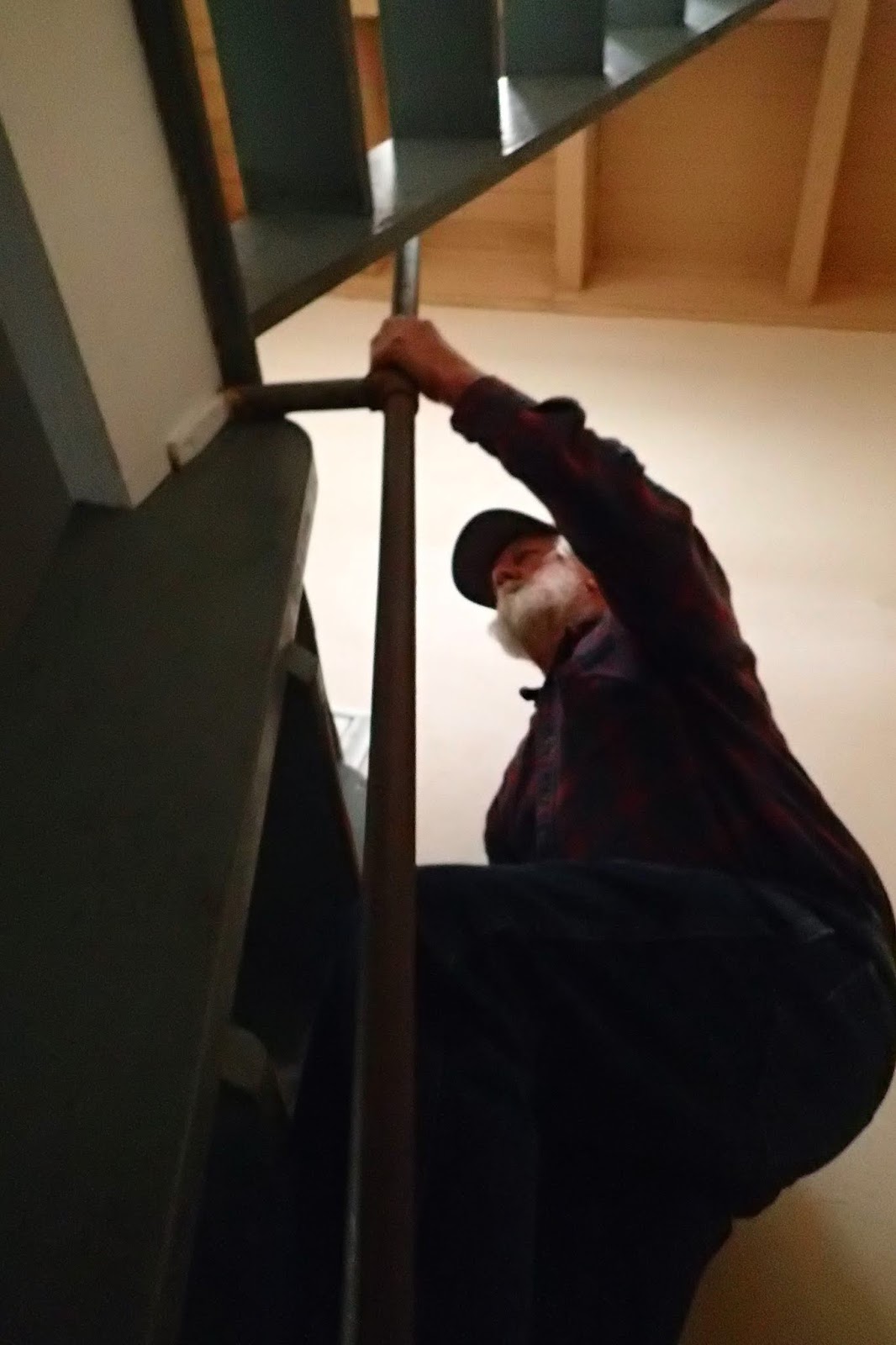
The Portsmouth Life Saving Station modeled after one designed for Quonochontaug, Rhode Island is maintained along with the other buildings of Portsmouth Village by the National Park Service. Graham is climbing the stairs to the observation room. Below is the view West.

Here is the view East across Ocracoke Inlet.

Graham asked me if I knew what this was. I told him I thought it might be a device for laying out rope so it would not tangle when it was rapidly deployed.

The rope was attached to a Lyle gun which fired a projectile carrying the line out to the ship in distress. The light line was then used to pull out a heavier line so a breeches buoy could be pulled back and forth removing passengers from the vessel one at a time. This system was used for wrecks that were with about 600 yards from shore. Further than that boats were used to reach the vessel in distress.


Just southeast of the Life Saving Building is a path that leads to the beach. There is suppose to be good shelling and a beautiful beach but as I followed the path it entered a thicket and the mosquitos quickly swarmed all over me. I retreated to the open and headed back to the boats. At the dock private boats were bringing tourists over from Ocracoke. Two boats came in while we were there. We spoke with the captains to get some tips on how to avoid the shoals on the way over to Ocracoke.

Sally is cleaning up a bit prior to our trip across the Inlet to Ocracoke.

Ocracoke is much higher above sea level. They have some beautiful trees.

We rented a golf cart and saw some of the highlights. A German U-boat sunk a British Naval vessel during World War II. The bodies of several British sailors washed ashore and are buried here.

This is a tree on the lighthouse grounds. I love its twisted trunk and the pruned and asymmetrical shape.

The Ocracoke Lighthouse was built in 1823 and stands 75 feet tall. It is still in operation. Monday night we had dinner at a local restaurant. Weather forecast was calling for winds from the Northwest at 20 to 25 knots. We decided if it was indeed blowing that strong in the morning we would delay our departure. It was well past dark when we got back to our boats. Graham and Carol and Jay motored off to find a quiet place to drop anchor. Our anchor was well set, but we were fairly close to what would be a lee shore. I did not want to sail around in the dark to find another spot so I decided I would deal with the lee shore in the morning. By 4 am the wind had picked up and veered enough that we were swinging up close to a dock. I sat in the cockpit armed with a paddle to push us off. We would swing into the dock. I would push off and we would swing back into the open. After a minute or two we would be up against the dock again.

During the night I listened to the weather forecast and it was calling for the wind to drop below 20 knots by late morning. We decided that if the wind eased we would go ahead with the crossing. The morning dawned bright and clear. I set two reefs. We double checked the sheets centerboard and rudder. The wind was at 20 knots and we were pinned on a lee shore between two docks. We would have to get this right the first time. I went forward to weigh anchor. Once the anchor was free the boat started drifting back towards shore. I had to get the anchor the rest of the way up and stowed in the forward well and then make my way back to the cockpit. I pulled the mainsail over and off we shot on a port tack.
We sailed back and forth across the harbor and out towards the sound. The wind was blowing over 20kts with stronger gusts. We could manage the boat fine in the harbor but we felt it was unwise to attempt the long unfamiliar crossing in these wind conditions. We dropped anchor near Graham and told him we felt it would be better to wait to see if the wind would drop off a little.
We relaxed in the cockpit, by noon it was still blowing hard and we had some lunch. Finally around 1pm the wind began to ease. This was late in the day to be contemplating a crossing that could take 8 to 10 hours. Jay and Carrol decided they would stay another night. Graham said he was OK either way. It was really too late in the day but I did not want to delay our return.
We began some final preparations and it was nearly 2pm when we waved goodbye to Carol and Jay and headed out of the harbor with Carlita leading the way. Graham wanted to explore the shoals around Ocracoke Inlet so we began our trip by retracing our track from yesterday. The wind soon dropped to around 15 kts and we had a wonderful sail back to the Wallace Channel.

We had been on a broad reach down to Ocracoke Inlet but as we entered the Wallace Channel we had to trim in our sails and head West northwest. We set a course for Brant Island Shoal. We began to pull away from Graham, but then he shook out his reefs and began to pass us. I considered taking a reef out but the sun was not far from the horizon and I would rather be over reefed with darkness approaching.

By the time we reached the tip of Brant Island Shoal the sun had gone down. Soon the moon began to rise. We knew this was going to happen, so I can't say we were surprised. We were tired, we had not had much sleep the night before and it had been a long day. It is getting dark and we still have 15miles to go to the mouth of the Bay River, 20 some miles to Chapel Creek. And wouldn't you know the wind began to increase and back till it was nearly on our nose. When the wind picks up the waves on the Pamlico build very quickly. These wave were only about 2 feet but they were steep and very close together. Sally went into the cabin to switch on the navigation lights and we settled down for the long slog ahead. I removed my sunglasses but I did not want to hunt up my regular glasses so I did without, my distance vision is not very good. In the choppy conditions I found it difficult to keep the boat on course. There were a few red lights visible but I could not take the time to determine what they were. I got a magnetic course from the gps then I would try keep to that heading using the compass. After a while I would check back with the GPS. Switching my vision from looking out for waves and obstructions, (We knew there were unlit poles marking the prohibited zone near our course.) to watching the sails, to checking the compass was difficult and tiring. At last I noticed a star 10 degrees or so above the horizon right on our course. Having a star on our course made it much easier. I could stay on course while at the same time watching for the wind, waves and obstructions. We could not see Graham we knew he was somewhere in front of us. We would learn later that he was actually quite close. He could easily see our lights, but unbeknownst to us his lights were not working.
Our bow plunged into one of the waves and sent water streaming up the front of the cabin and across the roof. I have never seen so much water come over the bow of SKORPA. At night for me on a sailboat everything is three times worse than during the day. We were not panicking but hunkering down aware of the growing fatigue and measuring the distance to the Bay River.
Slowly almost imperceptively the waves began to diminish. Then the wind eased as we entered the mouth of the Bay River. We became more aware of navigational lights and shore lights. Suddenly some yellow lights appeared just in front of us. I thought they were reflectors on a pole or some people in a small boat fishing. Sally called out to them. I turned the boat hard to starboard to avoid running into them. Then the lights receded a couple of miles back to the shoreline.
It was around 9pm when we came up to Bonner Bay. I had been looking forward to getting here for the last four hours. My plan had been to drop anchor as soon as possible and just collapse on my bunk. Now the river was quiet, the wind light, Skorpa moved steadily. All the tension had dropped away leaving relief and adrenaline. I suggested to Sally that she go into the cabin, call Graham, and change into some dry clothes. The night air was cool and we were wet and shivering. She hesitated at first to leave her post, but I assured her I would be fine.
I could hear her talking on the phone." Graham we made it!!" she exclaimed. " I know" he replied matter-of-factly. " I have been watching you."
We decided to continue on to Chapel Creek. We wanted to savor the moment. The magic of sailing quietly up the river at night was all the more intense because of the contrast with the wet and tense ride through the waves on the Sound. Sally fixed some crackers and cheese. They were so good. I shook out the reefs. Occasionally we could catch a glimpse of Carlita's sail up ahead.
We met up with Graham in Chapel Creek very near where we knew his dock to be. Clouds had moved in to cover the moon. In the darkness we could not see any landmarks. We just headed in the direction of the dock trusting we would see it before we ran into it. Sure enough when we were about 50 fifty feet off, the dock began to take shape out of the greyness.
It was a little after midnight. We had a little celebratory greeting on the dock and then we all retreated to our bunks for a quiet sleep.
No comments:
Post a Comment